A road trip to a land of surprising variety
Not long ago, we climbed into an old pickup truck and went west along one of America’s loneliest roads, passing over a roller coaster of desolate mountain ranges and endless sagebrush valleys–the forgotten floors of an ancient sea.
We were headed deep into The Great Basin, a destination that had been on my mind for some time, but not yet seriously. The goal was to spend a day or two camping and hiking in the area, to see if it was worth braving the mind-numbing travel I had heard of.
We first crossed through the small railroad town of Milford, Utah, along Highway 21, stopping briefly near a summer-vacated high school to rest in the shade. Feeling rested again, we drove on, following a ridge that quickly descended into the first of a series of deep valleys.
I wasn’t really sure what to expect, to be honest. I’d heard about the isolated west desert and could imagine it in my mind, being no stranger to arid places. But I couldn’t believe how long and straight some of the miles were, and it made the little nap at the school seem like more of a fortunate strategic decision rather than any sort of luxury. This was definitely not the place for a fatigued driver.
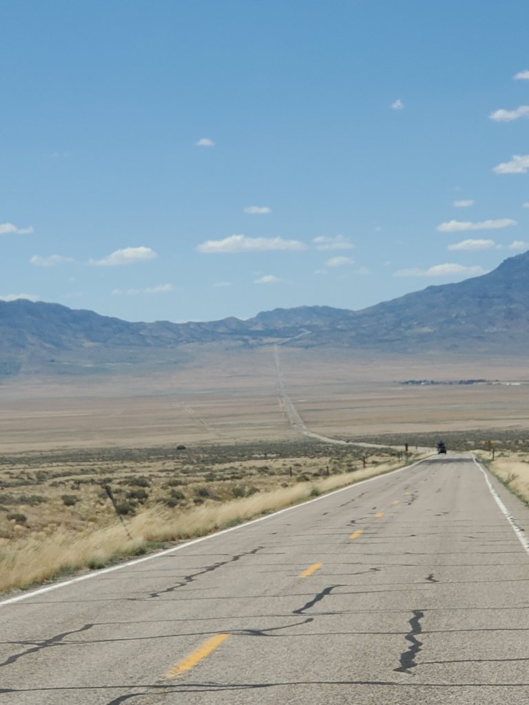
The bed of the truck was loaded with camping gear, and I was thankful that the air- conditioner was still working because the temperatures were pushing close to 100 degrees. Mirages floated like specters on the asphalt ahead and, at times, the simmering air made the distant trajectory of the roadway hard to discern.
While passing a place called Garrison, near the Utah state line, a lone pronghorn antelope grazed on the outskirts of a few patchy green fields, lined with clumps of ragweed. And within the next few minutes, we began to see the beacon of Wheeler Peak in the distance, standing at 13,063 feet in elevation, the second highest mountain in Nevada.
It was an incredible thought, but if Wheeler Peak were shifted a few miles east across the state line, it would still be the second highest mountain in Utah. There was something inspiring about this relatively small mountain chain standing alone, the highest for 180,000 square miles, and completely unattached to either the Sierras or the Rockies. As for the peak itself, it was named, climbed and surveyed in 1869 by Lt. George Montague Wheeler and his men. (https://www.nps.gov/grba/learn/historyculture/why-wheeler.htm)
Reaching the Park
After nearly 90 miles across the sagebrush, we reached the small town of Baker, Nevada and for the first time saw the gateway to Great Basin National Park. The scenery so far had been full of repetiton but ended with this–a close-up view of one of the most dramatic “sky islands” I had yet to experience.
We passed a single gas pump and a couple of restaurants beside a small collection of frontier homes. One restaurant had a surprising number of customers (either because it had really good food or the only food in town, I couldn’t be sure which). We saw only a few side streets that quickly trailed off into the desert, not surprising for a town with a population of less than 70.
Meanwhile, looming behind the town’s main drag, the treeless summits still harbored patches of snow. I thought about the glacier inside the park, on a protected slope– one of the southernmost of its kind in the U.S and reachable by trail. From our perspective down on the desert floor, it was hard to imagine anything like it.
The scenery so far had been full of repetition but ended with this--a close-up view of one of the most dramatic "sky islands" I had yet to experience.
At the west end of town, near the turnoff leading to Wheeler Peak, we found the first of two National Park Service visitor centers. Stopping here, we were greeted by a collection of maps and brochures along with a few freshly picked apricots leftover in a cardboard box. I learned that there was a second visitor center in the park, at nearby Lehman Caves, where the settler Absalom Lehman first planted the orchard in the 1800’s, later donating the land to the park.

The visitor center was cool inside, which was a welcome change. Two NPS employees worked behind plexiglass (presumably Covid precautions) at the gift counter. They confirmed to me that the park has no entrance fee, making it one of only a few in the West allowing access to whoever is willing to make the trek to see it. And it’s open 24 hours a day, 7 days a week. As for lodging, there are campsites for reservation only inside the park and limited lodging in Baker. Services in general are sparse.
After browsing some souvenirs, I glanced at a wall-sized map of the surrounding Great Basin itself, realizing just how big the overall area is–a whopping 200,000 square miles stretching across several states. The waters of the basin drain internally, creating a sort of island in its own right, not in terms of elevation, but in a hydrological sense.
“All precipitation in the region evaporates, sinks underground or flows into lakes (mostly saline). Creeks, streams, or rivers find no outlet to either the Gulf of Mexico or the Pacific Ocean.
https://www.nps.gov/grba/planyourvisit/the-great-basin.htm
While the visitor center beckoned us to stay, we weren’t here for just peripheral trivia. It was time to head up into the park and see it in a more intimate way.
Once back on the entrance road, we took the actual turnoff and began a nearly 5,000 foot ascent toward the Wheeler Peak Campground. Thankfully, despite some treacherous drop offs, the road was well-maintained and the old truck had little struggle reaching the top. While ascending, I was able to better appreciate the big skies, which were richly blue, with clouds seemingly larger than life.
Discovering an Alpine World
When we arrived at the base of Wheeler Peak, we settled into a campsite, taking some time before bed to stand in a lush meadow with a stunning view. As the light faded, we watched the high slopes trade patches of gold for a wash of blues and violets. At one point a mule deer crossed through a clearing nearby, pausing for a moment to survey the scene. It was a stunning end to a long day and we turned, reluctantly, back through the pines to our camp.

We awoke in the morning to chilly air, a distinct change from what we were acclimated to. After breakfast in the pines, we packed up camp and drove a short distance to the Alpine Lakes Loop trailhead. I’ve always had an affinity for mountain lakes and was excited to take this relatively short hike to see some of them.
We started out on the trail, crossing over a wooden bridge and taking the right fork leading to Stella Lake. The temperature was warming, but it was still perfect for hiking and the trail was well-used, but not crowded by any means.
We wandered through a series of meadows and stands of spruce, crossing over several small rivulets that flowed across the trail. The smell of pine was rich, but the climb was surprisingly steep at times and, in the high-altitude air, we had to pause often to catch our breath. Still, the best hikes are the unhurried kind, and while standing in the open areas we could feel the mountain sunlight and see the high peaks curling around us like a giant amphitheater.
Because of this terrain, however, Stella Lake was hard to see on approach and we were just beginning to wonder if we were still on track when an older gentleman appeared from the opposite direction. By the looks of his outfit and gear, long pants, sturdy boots and a hat, he was an experienced hiker.
“Hello,” I said, aware that not everyone wants to talk on the trail, but hoping he would. “Do you know if we’re close to Stella Lake or do we have a ways to go still?”
“It’s actually just right there,” he said, pointing behind him and smiling.
“Okay, great. Does the loop keep climbing from there or does it level-off and head back down? I’m just wondering if we should keep going afterward or turn around and go back down.”
“You should definitely keep going,” he replied. “It mostly levels off and loops back down to the trail head, and there’s another nice lake on the way. The hardest part is behind you.”
It’s sometimes rare to find good news on the trail. Often it seems that unexpected difficulty just has to be part of the experience. In this case, I was grateful to hear we were close and that the full loop would be the better choice. I thanked our trail friend for the intel and we continued on.
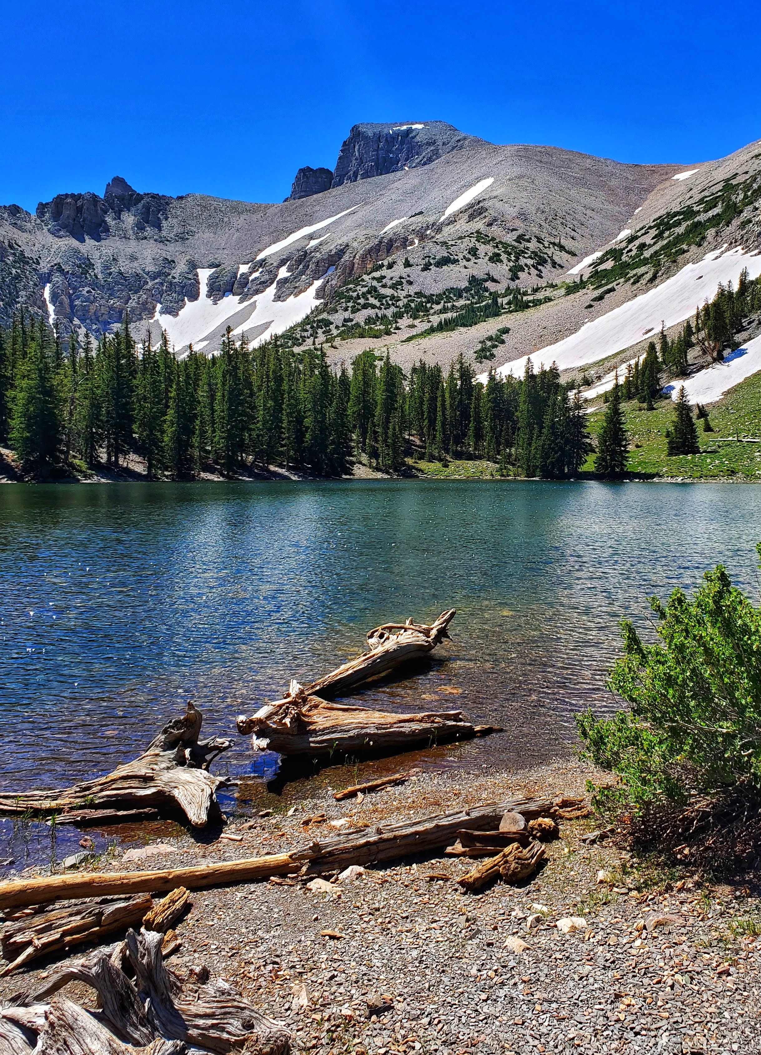
Sure enough, after about 150 yards, we came over a hill-crest to find Stella Lake at last, hiding like an emerald, in the trees and shale. The fish were jumping and a Limber pine stood, tall and trunk-twisted, nearby. We lingered here for some time, skipping pebbles, admiring chipmunks and contemplating what a short but sweet introduction this had been.
There was no longer any doubt that the Great Basin was full of surprises and hidden charms–small roadside towns, towering peaks still holding late summer snow, a glacier, apricot orchards, deep caves, magical alpine lakes, clear night skies and even an ancient grove of Bristlecone pines that we unfortunately had to bypass (until next time).
Even though our experience was brief, there was an overall feeling about this place that stuck with us–a beautiful consistency of contrast that was tangible enough to carry home.
