The path along the Virgin River was flooded a few nights ago as we surveyed the route from the top of the trailhead. Ample rains had left mud and about eight inches of water for nearly a hundred yards along the trail.
It wasn’t exactly an impasse, just cause for pause. We decided to press on, knowing that hiking isn’t just about sightseeing and meandering. Sometimes there should be some struggle–some challenge to overcome.
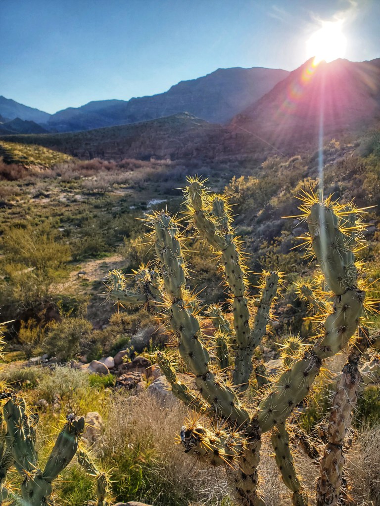
And, despite the mud and a few dangerous looking Chollas close to the trail, it was settling down to be a beautiful evening. The surrounding canyon walls reflected the lowering sunlight which sparked colors among a few patches of early wildflowers and whitewashed the log jams and snags of deadwood along the floodplain.

Soon we were making our way around the dirty puddles, over higher ground, sidestepping carefully at times between creosote and a barbed wire fence. Once back on the BLM trail headed south, my eyes raised from my feet to the skies. All around us was the settling peace of the desert at dusk.
As I often do while hiking, I thought about the natural (and unnatural) history of the scene. The Virgin River Gorge descends on a fairly steep grade from Southwestern Utah through the Arizona Strip and toward Las Vegas. It’s mostly known as a route for Interstate 15, whose footprint was blasted out of the rocks in 1973 as one of the costliest projects in the history of the Interstate system.
“The Gorge,” as it’s often called, is notorious among locals for having steep curves, brainless drivers and a seemingly never-ending barrage of construction projects. The highway has claimed many lives over the years and has witnessed some of the most catastrophic vehicular events imaginable. That narrow stretch of sky between canyon rims has too often ushered the passing of both smoke and souls.
Yet, for all its treachery, the highway is nestled inside a respectable display of desert beauty. The canyon walls, some of them hundreds of feet high, are supported by steep sloping foothills peppered with fallen boulders and hemmed by long deep ravines.
The Gorge lies on the upper reaches of the Mojave Desert at its eastern border with the Colorado Plateau. Accordingly, it has some of the typical vegetation of the Basin and Range Province of Nevada and California merging with the scrub and forbidding rockscapes of the higher elevations. This meeting of biomes, as is true in other places on earth, leads to an array of biodiversity.
On this night the young grasses were greener than perhaps I’d ever seen them, thanks to several “atmospheric rivers” that have brought record amounts of rain. Yucca, creosote, willow and the occasional barrel cactus all punctuated the slopes.
Yet the tallest and most prominent plants were the Joshua trees, which happened to be in bloom. Often in clusters, with spiny leaves on “outstretched” branches, they could be seen as sentinels over the landscape–that is if attaching such human characteristics can be tolerated.
I’m not the first one to do so. As the early pioneers described, the Joshua trees and their outstretched branches were like arms open in supplication to weary travelers of which there have been many. For 10,000 years, in fact, people have been traveling and inhabiting the gorge. The first were Mammoth hunters and later the Desert Culture people who lived a nomadic hunter-gatherer lifestyle here.
Between 200 A.D. and 700 A.D., the Anasazi, part of the pueblo culture of the Colorado Plateau, carried on farming in the area. Later the Paiutes settled and returned to a more Desert Culture lifeway.
In 1776 two Franciscan friars, Fray Francisco Atanasio Dominguez and Sylvestre Velez de Escalante, entered the region with a small party searching for a route between New Mexico and the California missions. Their effort fell short and they turned back to Santa Fe.
Later, in the early 1800’s, the route sought by the friars became a reality for fur trappers and Mexican traders who blazed what became known as the Old Spanish Trail. The famous explorer Jedediah S. Smith passed through the gorge in September of 1826, followed by others like him.
From 1830 to 1848, Mexican traders from Santa Fe and Taos took annual caravans through the area. However, it appeared they usually made a more manageable crossing using the Beaver Dam Mountains (now the route for Old Highway 91) some 15 miles to the north.
At about the same time as the trader caravans, the Mormons began to use the same route to connect growing communities in Utah with goods in Los Angeles. (Courtesy BLM kiosk at Virgin River Gorge Recreation Area “A Thoroughfare of History”)
There was no sign of pioneers or Franciscan friars this evening. And thankfully we were down below the highway where modern day traders and vacationers now rumbled past. Like hobbits sneaking toward Mordor, we pressed on while the automotive orcs marched on the pass above us.
Sometimes we could hear the traffic, which undoubtedly diminished our peace. But it was still possible to ignore the sounds and focus more on what the canyon really is and has been all along: the home of a river, a stairway of sorts from the high tables of red rock into the frying pan of the Mojave–a place where wildlife displays its fortitude against the elements and man.
When we reached the riverbank, we found the trail impassable due to spring runoff. Swift currents of brown silty water rushed downward toward Lake Mead. While not very deep, the speed with which the water passed was enough to prevent any further travel.
This time turning back, we followed a sandbank to the East, through stands of willow still bare from the long winter. In the sand we saw the tracks of insects and animals. Stink bugs, centipedes, the long rear paws and small forepaws of jackrabbits. There was the occasional lizard track mingled with the doodles, love notes and sand castles from children who had come before.
After returning to the trailhead, we decided to take one more hike to the top of the hill above the campground. The blooms on the Joshua trees were more ornate here and from this vantage we could see just how tightly the highway and surrounding rock had been fit together.
As the sun dipped below the horizon, it cast a purple light over the canyon rim. The bats were beginning their nightly flittering, hopefully, to eat their fill. It was an open and glowing ending to a muddy and obstructed start. A reminder that journeys, like places, can change. And sometimes they can be entirely different all at once.
